


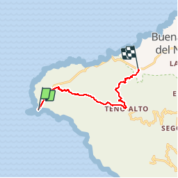
Punta de Teno- Teno Alto - Casablanca

karawatsj
User

Length
10.2 km

Max alt
780 m

Uphill gradient
796 m
Km-Effort
20 km

Min alt
0 m

Downhill gradient
687 m
Boucle
No
Creation date :
2019-12-08 10:33:37.582
Updated on :
2019-12-08 15:31:35.402
4h11
Difficulty : Very difficult

FREE GPS app for hiking
 SityTrail
IGN / Geographical institutes
SityTrail Plus
The world is yours!
About
Trail Trail of 10.2 km to be discovered at Canary Islands, Santa Cruz de Tenerife, Buenavista del Norte. This trail is proposed by karawatsj.
Photos


Positioning
Country:
Spain
Region :
Canary Islands
Department/Province :
Santa Cruz de Tenerife
Municipality :
Buenavista del Norte
Location:
Unknown
Start:(Dec)
Start:(UTM)
311791 ; 3136677 (28R) N.
Comments